
Originally published at blog.conifercountry.com
Pondering the 2016 hiking season…
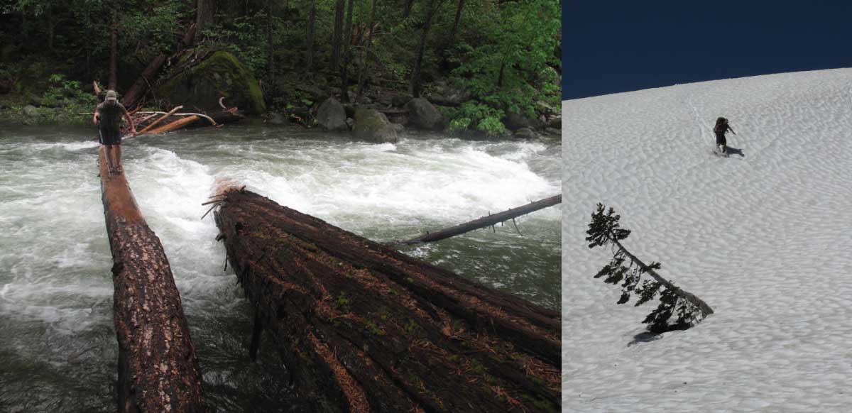
I have tracked how Klamath Mountain snowpack is correlated with the beginning of summer hiking season since 2003. In 2009 I started the Bigfoot Trail on the summer solstice, and it worked out perfectly—I found the perfect mix of snow, open trail, and manageable river crossings. In 2011 I began a section hike from the Trinity Alps to the Siskiyous on June 29th in a snowstorm and we trekked across snow for nearly two weeks while in the Trinity Alps and Marble Mountains. Our time also included numerous, often stressful, fords of raging rivers in the low-country. What follows is an analysis of the El Niño winter we are emerging from and what snowpack trends seem to be saying about the 2016 hiking season.
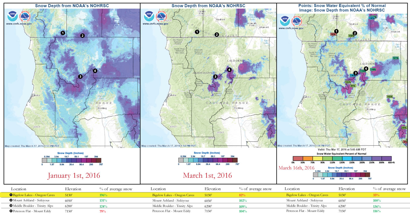
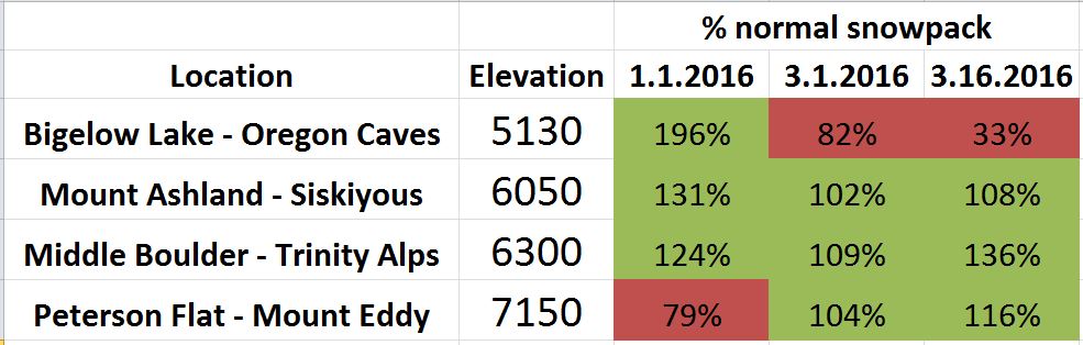
There is limited data for snowpack in the Klamath Mountains, with only only 6 locations updated frequently enough to present information here. But the trend seen in this limited data set is that we are having a just above “normal” year for snowpack—but it appears this is only true above 6000′. The regional weather trends since the big storms in late December 2015 has been that storms are warming, meaning higher snow line. Check out the Bigelow Lake Station (1) data below for proof of this statement. The times between storms have been, on average, sunnier and warmer. With average daily temperatures rising due to climate change the snow pack is melting faster and earlier in the season.
Obviously, I have no power to predict the weather patterns this spring. There could be a cold, wet weather pattern that sets in between now and the beginning of summer which significantly delays the ability for hikers to travel through the high country. However it appears that, even with another major storm or two, summer high-country hiking will be open for travel starting in early June.
Areas for consideration:
How snowpack could impact a hike when starting southbound on the Bigfoot Trail before early June.
- Section 1
- Average elevation in the Yolla Bolly-Middle Eel is around 7,000′ but the walking is mostly along open ridgelines, so snow should not be a major issue.
- Watch for the crossing of the upper South Fork Trinity Mountain.
- Section 3
- Fording Stuarts Fork is the toughest crossing on the trail.
- The pass and basin around Caribou Lake will hold late snow
- Snow will be encountered regularly between Packers Peak and Fish Lake
- Section 4
- Snow will only be an issue around Waterdog and Russian lakes
- Section 5
- 6 North Fork Salmon River fords start this section
- Wooley Creek must be crossed once
- Entire section of the PCT between Marble Valley and Grider Creek has high potential for snow, especially on steep north-facing slopes.
Hi Michael,
I’d like to hike the trail again this year but am concerned about the route between Yolla and Trinity Wilderness. I made my own route up through Wildwood and Hayfork. I was wondering what route you recommend. It seems that forest roads meander about and don’t stick to northern or southern directions. Walking on roads is one thing, but the rancher’s dogs are another. I guess they don’t know the difference between a thru hiker and someone who might be up to no good.
Also I like to get your take on the new Lake Berryessa wilderness as a connection south towards our area (Santa Rosa)
Thank you
Ray
Ray- the route I recommend is called the Bigfoot Trail :)! Yes, there are a few issues but the map set describes them all.
Hi Michael,
I’d be happy to purchase the map set, but I’ve got good forest service maps of the area between Yolla and Trinity. If the Bigfoot route doesn’t offer something that keeps me at least on forest land, then it’s not much use to me because it’s unlikely I’ll run that gauntlet again. The route on the poster looks like the one I took. I love bears, don’t like dogs! I’ve been attacked by pit bulls before, I’ll never be the same.
Also, are you looking at this Lake Berryessa/Snow Mountain tract at all?
I’m considering a hike that starts in the Trinity and follows the rest of the route to Crescent.
I would like to confer with you on trail specifics. If you’re willing to take time to do that, I’d be happy to make a donation to the Trail.
Ray
Hi Ray- We now have an interactive map that you can view at high resolution.
Almost all of the route is on National Forest and that which is not we will work to reroute in the future. I’m intrigued by the Lake Berryessa/Snow Mountain region and the potential to link that all up for a coast range hike — maybe even all the way to the Condor Trail!
Happy Trails.